

GLONASS is an abbreviated form of the second GPS system, built by Russia. The system was launched in the year of 1982 and from then it has been modified till GLONASS K2. Another version of the same GPS system in still under development and will tentatively be launched in the year, 2025. The working of the system is to locate the closest spot of your cell phone. The performance is enhanced through a chipset, placed in your smartphone.
Difference of GLONASS from GPS
GPS is the locater, which has been developed by US, but the same network is not used by Russia. They use separate trackers, and that is done through separate set of satellites. The functioning of the two systems are almost same, but the resource used in them are totally different. Some of the differential features in the system are as follows:
-
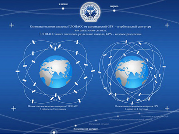
GPS uses 31 satellites to locate the particular locations, whereas GLONASS uses 24 satellite view, as of now. It is continuously increasing, as the new versions are coming up.
-
The distance at which the satellites are placed and they are viewing the positions is also different. Where GPS is located at an orbital height of nearly 19 thousand kilometres, GLONASS is placed at a distance over 21 thousand Km. Hence the periphery or the locus of locating the positions will all be different.
-
The coding style of GPS is CDMA, whereas the coding style of GLONASS is FDMA. This makes a wide difference in application of the devices. Frequency difference of the two application is also there.
-
There are some of the advantages of using GLONASS over GPS. Where funding a location is easier using GPS, accuracy level is there more in GLONASS. Tracking of the location is better done by the Russian Federation created application. The accuracy level of the GLONASS system id 2 meter more than GPS. This indicates the increase of future use of the system.
Cost and Use
Cost of the GLONASS system is more than that of GPS. Russian Government and Federation is trying the best to reduce the cost of the system, and for that they are continuously updating it, after rigorous research. Previously the location was only tracked through GPS. From iPhone 4S, both the systems are used to track the location and fetch the temperature and other details accurately.
Developing projects
The best thing that this evolution has done is to increase the accuracy level of Google map. Real time tracking of the locations and other supports are eased for Google, when GLONASS is there to assist GPS tracking system. There are other three systems that are under development. One of them is from Europe, where 30 satellites will be working to give the feed, China with 35 sets ready to be launched in 2020. India is developing one in the ISRO, all set to be released in this year. So, tracking will be made easier and even more sensitive. It will be ideal to restrict the crimes, but before that to get accuracy in the different feeds.